Detailed Overview of Cau Giay New Urban Area: The New Administrative - Economic Center of the Capital
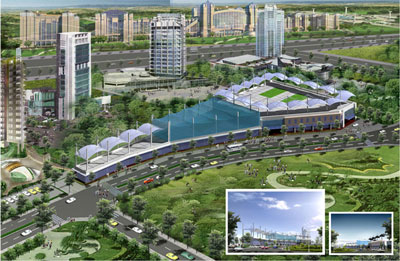
The Cau Giay New Urban Area is one of the key urban planning projects in Hanoi, designed to become a new economic and administrative center, meeting the demand for relocation and reorganization of headquarters of central and city-level agencies. With its large scale and synchronized planning, this project not only addresses population redistribution but also shapes a modern and civilized urban appearance in the western area of the capital.
Project Overview and Scale
The Cau Giay New Urban Area has a total planned area of nearly 287.8 hectares. This is a multifunctional urban area, built in a synchronized and modern manner to serve Hanoi’s strategic development goals. The project is invested by the Vietnam National Construction and Import-Export Corporation.
The urban area is located within the administrative boundaries of several wards of Cau Giay District and former Tu Liem District (now Nam Tu Liem and Bac Tu Liem Districts), including Quan Hoa, Dich Vong, Yen Hoa, Trung Hoa (Cau Giay District) and My Dinh, Me Tri (former Tu Liem District). Of which, the land area within Cau Giay District accounts for about 73.2% of the total.
The Cau Giay New Urban Area is planned to accommodate approximately 27,000 residents and around 100,000 service workers, with a total floor area for public buildings, offices, trade and services of about 2 million m².
In terms of market value, the project currently has a wide price range, reflecting the diversity of real estate types, from 76.17 - 673.02 million VND/m².
Strategic Location
The Cau Giay New Urban Area has a prime location, serving as the western gateway of Hanoi with a convenient transportation and regional connectivity system. The official address is on Dich Vong Street, Yen Hoa Ward, Cau Giay District, Hanoi.
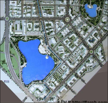
According to the 1/2000 detailed planning map, the boundaries of the urban area are clearly defined:
- North: Adjacent to Cau Giay - Xuan Thuy Road.
- West and Southwest: Adjacent to Ring Road 3.
- East and Southeast: Adjacent to inter-regional roads through Dich Vong Ward and subdivision roads through Yen Hoa Ward.
This location allows the urban area to easily access major transport routes, including urban railway lines and public bus systems, ensuring a road density of 8 km/km² within the planned area.
Planning and Urban Infrastructure
The planning of the Cau Giay New Urban Area is divided into 6 main functional zones, ensuring clear separation between administrative, economic, and residential areas:
- Southern area of Xuan Thuy Street (35.15 ha)
- Southern area of Cau Giay Street (24 ha)
- Dich Vong Urban Area (19 ha)
- Nguyen Phong Sac Street area (123.55 ha)
- Eastern area of Ring Road 3 (43.39 ha)
- Urban park area (36.7 ha)
Land Allocation and Functions
The total area is allocated for different purposes as follows:
- Existing residential land: 37 ha, renovated and upgraded.
- New residential development land: 31 ha.
- Land for government headquarters (ministries, corporations): 27.9 ha.
- Land for land-use auctions: 13 ha.
- Clean industry / knowledge-based industry land: 7.72 ha, non-polluting and noise-free.
High-rise buildings are located along Ring Road 3 and main roads, gradually lowering toward residential areas inside. Building heights range from 5–21 floors, mainly serving offices, commerce, services, and clean industrial production.

Spatial Axis and Parks
The urban area is designed with large green spaces, highlighted by the spatial axis connecting: Yen Hoa Park - Military Exhibition Center - National Exhibition Fair Park. This axis includes large squares and covered walkways, serving community events and public gatherings. The central square, with an area of 1.32 ha, is developed with landscaped gardens and water fountains, creating an architectural and social focal point.
Design and Residential Structure
The design of the Cau Giay New Urban Area aims to create a modern urban center with high-rise buildings. Building heights are planned in detail along main routes:
- Nguyen Phong Sac axis (from Xuan Thuy to inter-regional road): Buildings are 7–9 floors, with the highest point at the central square reaching 15 floors.
- Inter-regional axis (from Cau Giay to Ring Road 3): Buildings gradually range from 5–7 floors, forming a green corridor connecting Yen Hoa Park.
Residential Units
The urban area is divided into 3 residential units, each fully equipped with public infrastructure such as schools, commercial centers, and ward administrative offices:
- Unit 1: Includes existing residential areas south of Xuan Thuy Street and part of Nguyen Phong Sac extension. Estimated population: 10,000 people.
- Unit 2: Includes existing residential areas south of Cau Giay Street and part of Nguyen Phong Sac extension. Estimated population: 7,000 people.
- Unit 3: Includes remaining residential areas south of Cau Giay Street, Dich Vong Urban Area, and part of Nguyen Phong Sac extension. Estimated population: 10,000 people.
This division ensures balanced social infrastructure and quality of life, turning Cau Giay New Urban Area into a unified, modern, and convenient complex.
Conclusion
The Cau Giay New Urban Area is a strategic project, not only a residential place but also an important working and commercial center of Hanoi. With detailed planning, synchronized infrastructure, and investment from the Vietnam National Construction and Import-Export Corporation, the project affirms its role as a model urban area, contributing to the modernization and sustainable development of the capital.